

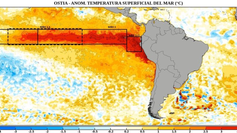
The Pacific is accumulating enough heat to raise the alarm among climate scientists and international meteorological agencies. The World Meteorological Organization predicts that the phenomenon called “El Niño” is destined to enter the narrow category of the most intense episodes ever observed in the modern era, modifying global atmospheric circulation.
For the August-October 2026 quarter, the average equatorial Pacific surface temperature anomaly is expected to be around +2.9°C, with further strengthening possible towards November. But some particularly extreme climate simulations have shown the possibility that the temperature of the central Pacific will rise much more than the expected average, up to values close to or above four degrees above normal.
What is a “super El Niño”
However, among the most impressive precedents is the 1877-78 event, reconstructed through observations of the time, historical ocean data and indirect climate indicators. Some of the largest documented droughts in modern history simultaneously affected large regions of India, China, Brazil, and Africa. Crops collapsed, food supplies dwindled, and millions of people died from starvation and disease.
A new El Niño of exceptional intensity would not automatically produce a catastrophe comparable to that of the 19th century. The world has tools that did not exist in 1877: satellites, ocean buoys, climate models, warning systems, crop monitoring, global food markets and international organizations capable of intervening before a crisis turns into a widespread famine.
El Niño can also be predicted several months in advance, allowing governments to prepare food reserves, modify crops and organize emergency interventions. However, this does not mean that an extreme event would be without consequences.
Precipitation anomalies associated with El Niño can simultaneously affect some of the planet’s major agricultural areas. A prolonged drought in multiple producing regions could reduce the supply of grains and other raw materials, driving up prices on international markets. At the same time, other areas may face torrential rain, floods and landslides.
Where the risks of drought and floods increase
Projections indicate potentially drier than normal conditions in parts of the Indian subcontinent, Australia, Central America, the Caribbean and northern South America. In other regions, such as parts of the Horn of Africa, central Asia and southern South America, the chances of above-average precipitation are increasing.
The relationship between El Niño and the European climate is much less direct than that observed in other parts of the planet, but seasonal forecasts nevertheless indicate a greater probability of above-average temperatures for Southern Europe, together with the possibility of overall heavier rainfall in some phases of the season. The two conditions are not necessarily contradictory. A season can be warmer on average and at the same time record rainfall concentrated in a few particularly intense episodes.
The exceptional fact is the combination of a rapidly strengthening El Niño and a planet that is already much warmer than during major events in the past. Global oceans store an increasing amount of energy and the atmosphere contains more water vapor. This can amplify some of the weather extremes associated with natural climate swings.
Boiling sea: the Mediterranean has exceeded 30 degrees in temperature