

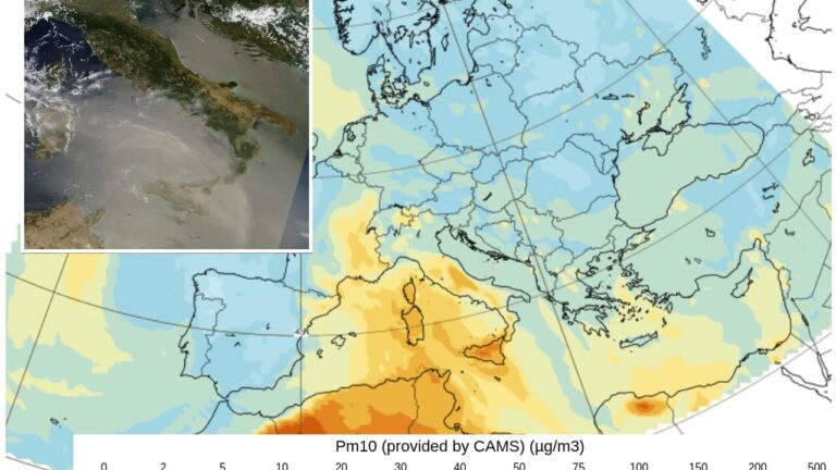
Milky skies, an almost unreal light and that feeling of heavy heat suddenly returned after a few days of respite. To understand what is happening in Italy, just look at the satellite image of the Mediterranean: a gigantic cloud of dust coming from the Sahara extends from North Africa towards Sardinia, Sicily and the Peninsula. The concentration is such that in the image the Sicilian island almost seems to disappear under a yellowish-grey blanket.
Data from the atmospheric sensor mounted on the European Landsat satellite also confirm how the African anticyclone brought Saharan dust to our country. But how long will it last?
Clouds of dust
Desert dust can travel thousands of kilometers. The winds lift enormous quantities of particles from the arid regions of northern Africa and carry them towards the Mediterranean and Europe. A portion remains in the upper layers of the atmosphere, while a portion may reach the ground, temporarily increasing particulate concentrations. This is why, during these incursions, the classic reddish patina can deposit on cars, especially when the sand is dragged to the ground by the (rare) rain.
The phenomenon has the same origin as the heat wave that will affect our country for a few days: the atmospheric circulation is attracting air masses coming directly from North Africa towards Italy. Between 27 and 28 August the heat will become particularly intense again in the South and on the major islands. In Sicily and Sardinia the maximum temperatures may locally exceed 40 degrees, while very high values are also expected in Calabria, Puglia, Basilicata and in the internal areas of the central regions.
How long will it last
Forecasts from the European Copernicus center estimate a reduction in dust in the air from Monday, but temperatures will remain high for at least part of next week. The trends for the beginning of September in fact continue to show maximums (and unfortunately also minimums) generally higher than the averages, especially in the Mediterranean and in the central-southern regions.
Those “cool” days that were actually normal
The new wave comes after a few days in which, especially in the North, many had the feeling that the cool weather had finally arrived. In reality, something much less extraordinary had happened: temperatures had simply returned to around normal values for the second half of August.
The context, moreover, is that of a European summer marked by exceptional temperatures. According to the European climate service Copernicus, June 2026 was the second warmest June on record in Europe, with an average temperature 1.78 degrees higher than the reference period 1991-2020. Even more significant is the data relating to Western Europe: putting June and July together, 2026 recorded the warmest two-month period in the Copernicus series that began in 1979, with an anomaly of 2.79 degrees above the climate average.