

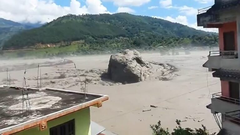
It was not an earthquake that caused the devastating flood that engulfed a vast area between Nepal and Tibet on August 26th. Essentially, the opposite happened: the collapse of an enormous mass of ice and rocks produced vibrations so strong that they were initially interpreted as an earthquake, before unleashing a gigantic flow of water, mud and debris downstream.
The USGS, the United States Geological Institute, clarified the dynamics. In the first hours of the emergency, its instruments had recorded an earthquake of magnitude 4.4 in the area. However, after re-examining data from seismic stations, long-period waves and satellite images, American scientists corrected their assessment: “no earthquake occurred”. The signal instead came from a glacial collapse to which an equivalent magnitude of 5.2 was attributed.
The glacier that shook the mountain
Initial reconstructions indicate that an avalanche composed of ice and rock fell in the area of the Lhende Khola, a tributary of the Bhote Koshi, near the border between Nepal and China. The mass would have blocked the waterway at least temporarily and then suddenly released an enormous quantity of water and debris downstream.
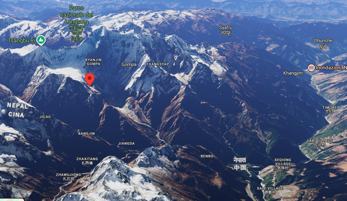
This is the explanation that also emerges from the analyzes of the International Center for Integrated Mountain Development (Icimod), the research center based in Kathmandu specialized in the Himalayas. The observations show the extraordinary violence of the event.
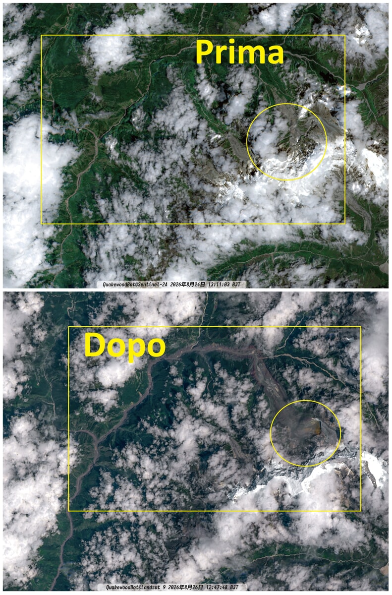
According to a first reconstruction, at 8:37 am, local time, on August 26, 2026, a block of ice over 600 meters wide broke away from a glacier at an altitude of 5,200 meters, falling for over a vertical kilometer to the bottom of the valley towards the Bhote Koshi river. A Chinese photographer (HeyMu.Travel) would have accidentally immortalized the precise moment of the avalanche’s release.
Initial estimates speak of how the collapse would have generated a potential energy equal to 10-15 times the explosions of Hiroshima: an impact so violent enough to instantly pulverize ice, rock and snow into slush.
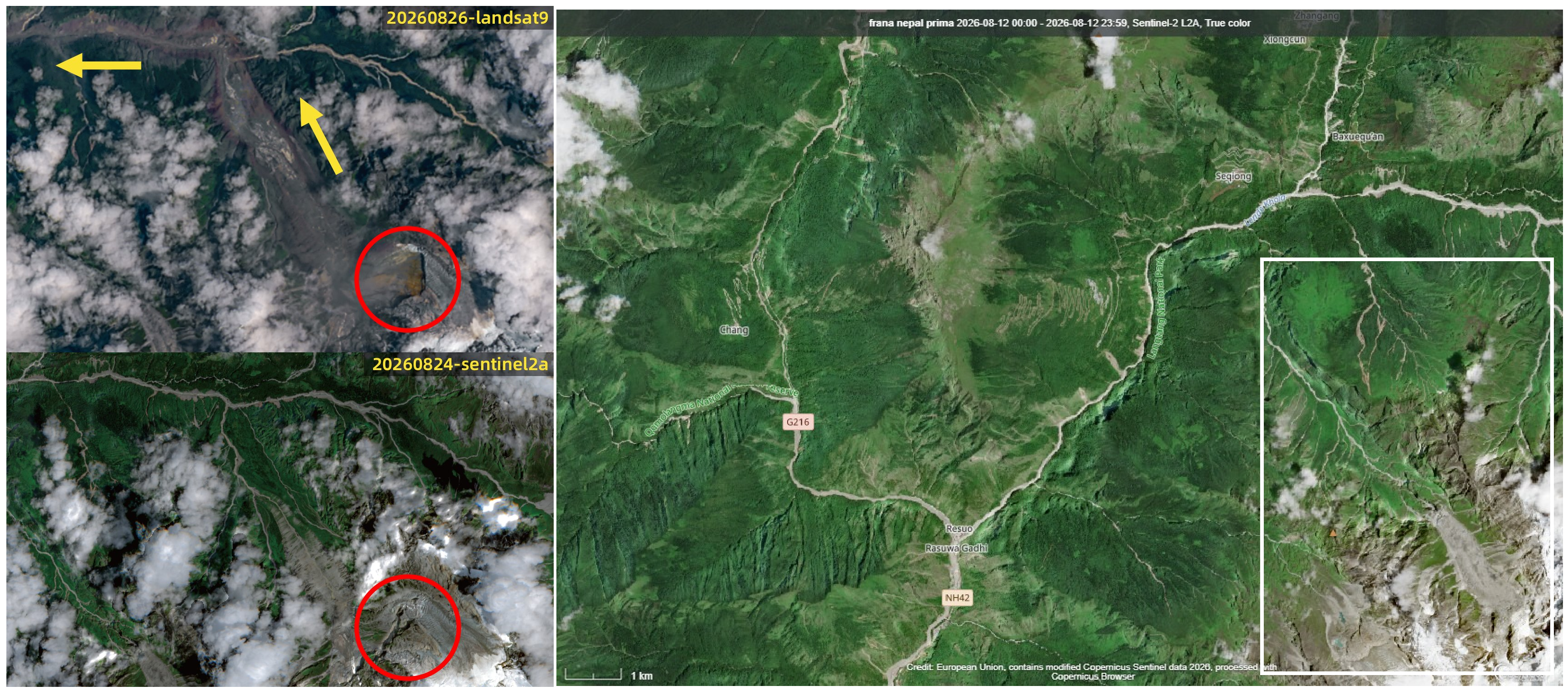
This massive avalanche of ice and rock – more like a landslide in this case – hit a mountainside, falling into the Lhende Khola River, a tributary of the Bhote koshi and Trishuli rivers, which flow from China to Nepal, often through deep gorges. A video published by some Chinese Osint shows the first moments of the landslide taken from a Tibetan village located on the opposite side of the Langtang mountain from which the avalanche broke off.
The effect was an imposing and apocalyptic wall of water, mud and heavy debris that violently devastated the mountain settlements downstream and the structures of the border between China and Nepal, reaching the Jilong Pass in just twenty minutes, and breaking over one hundred kilometers into Nepalese territory.
The images show probably the worst debris flow ever documented in human history. On the Trishuli river, at Galchhi, the water level rose to nine meters in just half an hour.
The flood followed the Bhote Koshi and Trishuli system, hitting villages, roads and hydroelectric plants. In some areas it was not raining significantly when the wave arrived, which helped catch the population by surprise. Entire buildings remained buried in the mud, while vehicles, bridges and parts of the road were swept away by the current.
A surveillance camera on the Chinese side of the Gyirong river port captured a brown wave several meters high that submerged and engulfed a six-story building within seconds as people tried to escape.
Now in place of the border station there is a lake with a rock barrier over one and a half meters high.
In Nepal, the wave overwhelmed cities in the Trishuli river valley, in the Nuwakot district north of Kathmandu, and in the Bhotekoshi river valley east of the capital.
At least 469 dead and 2,400 missing
The balance remains extremely uncertain and is destined to change as research continues. Nepalese and Chinese authorities reported at least 469 dead and 2,400 missing.
Satellite images released by Vanator show how the Rasuwagadhi border crossing between China and Nepal has been completely destroyed.
The missing tourists
The number of foreigners involved is particularly high: the heart of the Himalayas, the “roof of the world”, is a popular destination for hikers and mountaineers. Among those missing in Nepal are Italian, Indian, American, Australian, British and Canadian citizens.
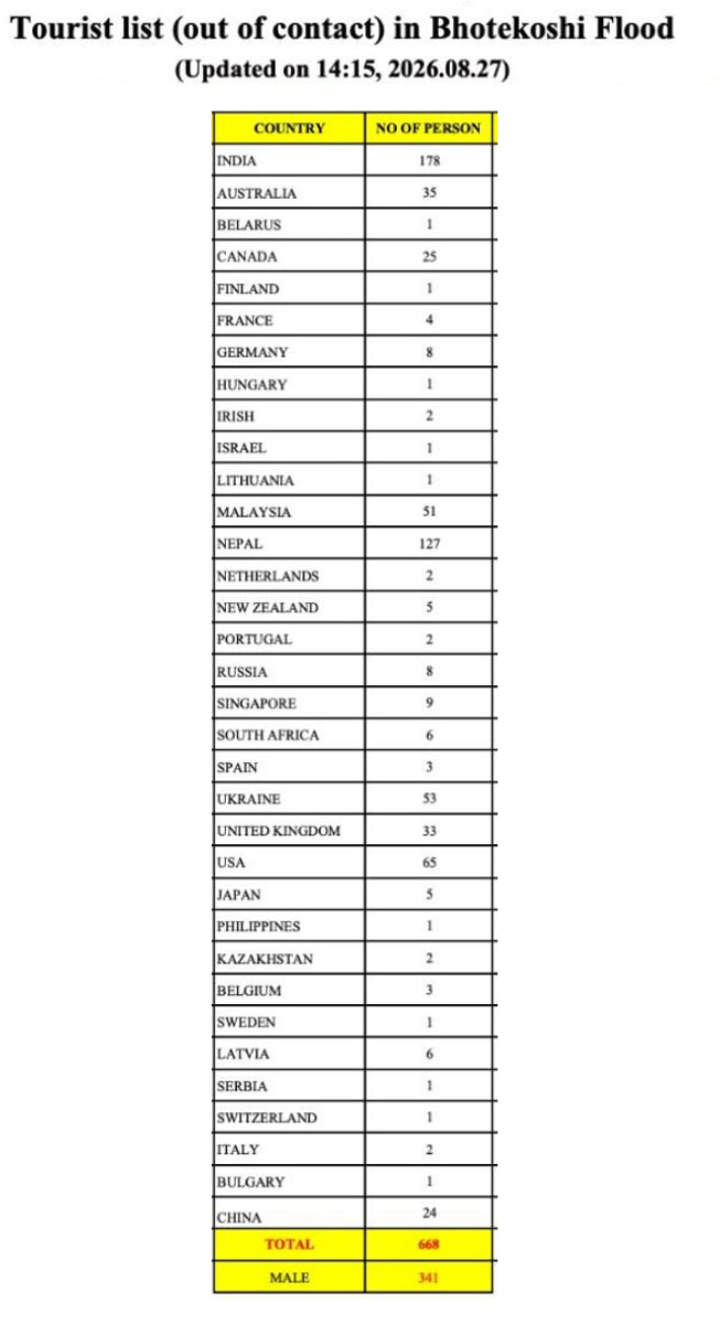
Many were traveling through the region to reach Mount Kailash, in Tibet, a sacred place for Hindus and Buddhists.
The emergency is worsened by the destruction of infrastructure. In Nepal, 35 vehicle bridges, 45 suspension bridges and around 40 kilometers of asphalt roads have been swept away, making it very difficult to reach some of the most affected locations. The army and rescuers are also using helicopters, while Nepal and China have mobilized men and vehicles to search for survivors.
China activates emergency response after mudslide hits Xizang border port
Chinese authorities have launched full-scale rescue operations after a mudslide in Nepal caused severe casualties at China’s border port of Gyirong in southwestern Xizang Autonomous Region on Wednesday… pic.twitter.com/fJP5UAYYIy
— China Military Bugle (@ChinaMilBugle) August 26, 2026
A case that is far from isolated
Finally, there is an element that worries scientists. The Lhende Khola river system itself was affected by two major floods in the space of just 14 months. In 2025, a flash flood caused by the emptying of a glacial lake in Tibet had already caused victims and destroyed strategic infrastructure along the border between Nepal and China.
Warming Himalayas are rapidly changing glaciers, snow and permafrost, raising scientists’ focus on ice avalanches and flash floods.
Marmolada, the collapse of the glacier (11 deaths) was “the fault” of the anomalous heat
The Tibetan-Nepalese disaster, in addition to bringing to mind images of the tsunamis that hit Indonesia (2004) and Japan (2011), recalls two other tragedies more linked to climate change and the incorrect design of infrastructure in fragile contexts.
The collapse of the Marmolada glacier in the summer of 2022 which swept away 11 people. The event was documented by several videos recorded by hikers who were on site, who helped in the analysis of the causes of the collapse. The seismic energy released by the event was comparable to a magnitude 0.6 earthquake.
Unstable mountains, collapsing glaciers and the risk map that doesn’t exist: the areas most at risk
But the Derna flood in Libya is the deadliest climate disaster in the world to date: it killed four thousand people in a few hours on the night between 10 and 11 September 2023.
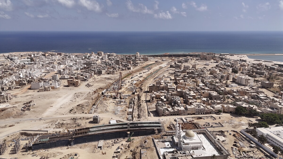
Storm Daniel – one of the few Mediterranean cyclones ever recorded – hit Cyrenaica, discharging exceptional quantities of rain (around 440 millimetres): the failure of two dams upstream from the city concentrated the mass of water in the Wadi Derna, the normally almost dry waterway that crosses the Libyan city. The flood arrived in the town center like a gigantic flood wave, obliterating entire neighborhoods, demolishing entire buildings and dragging cars and people into the Mediterranean Sea.
Dossier is the exclusive subscription investigative section of The Vermilion. If you want to support our journalistic work and subscribe, Click here.